
Packrafting the North Boundary: A multi-river traverse through Jasper National Park
- Tim Kelley
- Jan 1
- 7 min read

Updated: Jan 23

Why Packraft the North Boundary?:
The North Boundary is an excellent introduction to packrafting in the Canadian Rockies. With two sections of wilderness river connected by a well-established trail system, this 185-kilometer traverse is a great way to see the most remote corner of Jasper National Park. Complete with glacier vistas, impressive waterfalls, lush boreal forest, and moderate whitewater, this route has something for everyone.
ROUTE OVERVIEW
The North Boundary has primarily been known as a hiking traverse connecting British Columbia's Mount Robson National Park and Alberta's Jasper National Park. Given that much of the hiking route is paralleled by the Smokey and Snake Indian Rivers, the route has gained interest from packrafters after it was first completed as a packraft traverse in the summer of 2020. Subsequently, the July 2021 heat dome led to massive flooding in the area, which destroyed large segments of the Berg Lake Trail and closed access for 4 years. After extensive rebuilding, access to the trail was restored in the summer of 2025, which inspired us to check out the packrack traverse.
Difficulty and Flows:
The route is primarily class II-III in nature, with a few sections of harder whitewater and large falls that are easy to portage. Intermediate paddlers with strong wilderness skills would enjoy late summer flows, while more advanced paddlers would enjoy this route through the summer season as well as the opportunities for play and some extra-curricular rapids (IV-V). The main hazards along this route are a few large falls and more difficult canyon sections that are often preceded by distinct but must-make eddies. While I marked portage routes we found effective in the above map, good situational awareness will help you determine if higher water levels or your group's comfort might dictate earlier take-outs and longer portages. The trail is never too far away, and any group that found itself overwhelmed by the whitewater could revert to hiking.
ROUTE DESCRIPTION
Hike: Robson Meadows to Big Smokey River (26km)
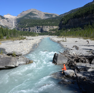
Starting at the Berg Lake Trailhead, the route begins with a stunning ascent through Mount Robson Provincial Park. Having been recently repaired, this initial stretch is once again one of the more popular hikes in the Canadian Rockies, and you will undoubtedly be sharing it with many others on a nice day. Over the roughly 15km ascent to Berg Lake, the trail gains 1000m in elevation. Many impressive waterfalls offer excellent spots to break and cool off. Berg Lake is framed by fantastic views of Robson and its glaciers that stretch down to near its shore. It was a nice place for a swim after a hot and sweaty climb. Beyond Berg Lake, the terrain levels as you leave the day hikers behind and cross into Jasper National Park. The trail also becomes noticeably less manicured and narrows into a single track as it passes Adolphus Lake. While it may be possible to begin your paddle at Adolphus Lake with higher flows, we continued along the trail until the confluence of the tributary from Coleman Glacier, which adds enough water to float a boat.


Paddle: Big Smoky River (17km)
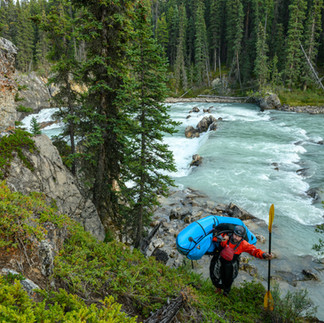
The Big Smoky bisects a scenic valley with great views of the alpine, including a few hanging glaciers. The low-volume braids that characterize the upper reaches eventually constrict into a channelized section with more engaging whitewater that builds before reaching a set of drops in a mini gorge. We opted to portage the first and run the second, with portage options on river left. The river opens again, and the whitewater eases before consolidating once more in the lead up to a second and more significant canyon. It would be easy to get lulled into this canyon given the fun read and run whitewater in the entry. While parts of this canyon look runnable, one particularly undercut wall without a good portage option made it an easy decision for us to pack up and finish the day by walking the trail for the remaining distance to Chown Camp.


Hike: To Chown Camp and Canyon Bypass (3km hike, 2km paddle)
Whether you plan to camp at Chown or just bypass the class V section of the canyon, a short section of trail offers an easy alternative. Once reaching the Chown, you will have to ford or ferry across the river to access the designated campsite. When it is time to return to the Big Smoky, it's an easy float down the Chown through some low-volume braids.


Paddle: Big Smoky below Chown (5km)
From the confluence with Chown, the Big Smoky stays consolidated and swift on its way down to the transition point. Be on the lookout for a small meadow on the river left before the river makes a turn back to the left and enters the 3rd canyon. This is a great spot to transition to hike mode. It's a short walk downstream to find the trail and the wooden bridge that crosses over the canyon.


Hike: Big Smoky to Snake Indian (36km)
Leaving the Smoky marks the start of the longest hiking segment of the route. While the trail has some downed trees and overgrown sections, likely due to less frequent usage or maintenance during the 4-year-long closure of the Berg Lake Trail, it is still well-defined and easy to follow. We traveled from Chown to Byng camps in a full-day push, but there is lovely camping on Twin Tree Lake that could serve as a different way to break up the trip. There is currently no bridge over Twintree Creek. While it was reasonable to ford at our late-season flows, high flows may require inflating boats to cross. While much of the hike is below treeline, the pass between Byng and Oatmeal camps traverses through a short alpine section that offers unobstructed views of the surrounding mountains. It may be possible to float the uppermost reaches of the Snake Indian from Oatmeal Camp on the afternoon diurnal, but some river-wide wood just downstream of camp dissuaded our attempt. Instead, we hiked a little more than 3 km beyond the camp the following morning to put in below where an additional tributary doubled the volume.


Paddle: Snake Indian River (98km)
The Snake Indian River is the longest segment of river travel on the traverse. I'm breaking the description into three different sections to provide some more specific detail:
Upper Snake Indian: (Put-in to Welbourne Camp)
Beginning as a low-volume creek, the Snake Indian starts with some class II boulder dodging. A small, shallow falls with wood necessitated a short portage with an option to put back in just below for a class III+ sequence ending in a fun chute. Below here, the river opens up and meanders through meadows and wetlands for most of its upper reaches. While the travel is slow, it allows for plenty of opportunity to soak in the views and scan for wildlife. Eventually, the current returns and a huge horizon line signals the approach of Upper Welborne Falls. We found that the Falls was reasonable to portage from the last eddy above the lip on river left before descending back to the river via the first available ramp (depicted on the map). From here, it is swift travel down to the riverside Welbourne Falls Camp.


Middle Snake Indian (Welbourne Camp to Snake Indian Falls)
A short distance below Welbourne Falls Camp lies Lower Welbourne Falls. The river starts picking up in pace during its approach to the falls, and where an island splits the flow is a good place to eddy out to assess portage options. There is a final eddy on the river left immediately above the falls, but there is no room for error in the lead-in rapid (III+/IV-). Once beyond the falls, an existing social trail leads down to the scenic pool at its base.
After a few more kilometers of braided channels, the river reconsolidates and picks up pace with fun II-II+ on the way to Snake Indian Falls. A corner with some offset ledges (III) signals that the falls are near. A generous eddy on river left is a welcome sight as you paddle towards the intimidating horizon line. The rocky promontory at the lip of the falls offers an incredible sense of scale. From the Snake Indian Falls overlook, we began our portage along an established spur trail that leads up to a juncture with an old road grade. After walking this wide trail downstream for a few minutes, we found a faint social trail breaking off into the woods on the looker's right, which brought us back down to river level below the falls.


Lower Snake Indian (Snake Indian Falls to Celestine Falls Trailhead)
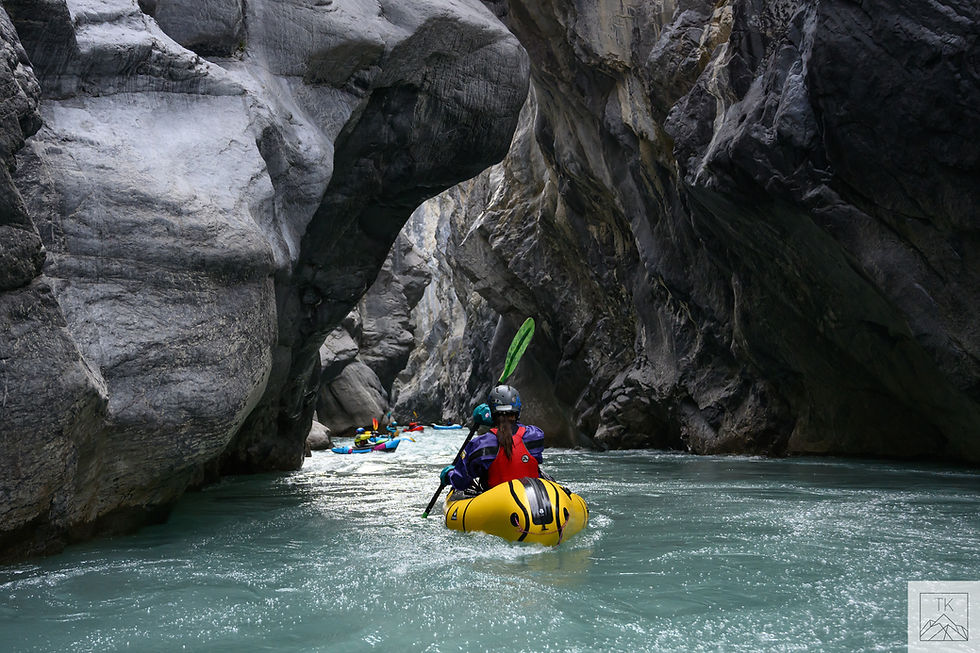
While this traverse is less of a whitewater-centric trip, the Lower Snake Indian is the definitive whitewater highlight. Primarily class II-II+ and never exceeding class III, the Snake Indian winds through miles and miles of playful wave trains set among beautiful low canyon walls. One particularly stunning section of canyon comes near the very end of the run. A footbridge marks the takeout and the final five-minute walk to the Celestine Falls Trailhead.


LOGISTICS
Jasper Permits and Campsite Selection:
Travel along this route requires a permit that includes reserved backcountry campsites through Jasper National Park. While this traverse seems poised to become a well-known packraft route, for now, the permitting system is built around usage by backpackers and through-hikers. While packrafters typically seek out camps that are at a natural transition point between paddling and hiking, operating within the bounds of Jasper's permit system requires packrafters to camp in spots that are a little less intuitive. Campsites should have an open latrine and bear hang, but a number of these required repair at the time of our trip. There are a certain number of "tent-pads" (max 4 people per tent) available per site, and a maximum party size of 10. To ensure you have the appropriate campsites for your traverse, it is worth booking well in advance (3 months gave us full choice over site selection). I have included waypoints to the camps we used in the embedded overview map. We found that a 5-night, 6-day trip was doable but pushy and that adding another day and considering a slightly different campsite progression would make for a more relaxed, 7-day trip. The map and descriptions below give an overview of the campsite options along the route.


Mt. Robson Permits:
With enough planning, it would be possible to camp in Mt. Robson Provincial Park, making for a shorter first day of the traverse. These permits are in high demand and are often booked by mid-winter. As such, it seems likely that most groups will spend their first night at Adolphus Camp in Jasper. This makes for a full first day but negates the need for a Mt. Robson permit.
Shuttle:
It is approximately a 2-hour drive from the takeout at the Celestine Lake Trailhead in Alberta to the Berg Lake Trailhead in British Columbia. The Celestine Road is a narrow gravel road not recommended for low clearance vehicles. It is a one-directional road switching between outbound and inbound traffic every half hour to eliminate bottlenecks at narrow sections. Check the park website for the latest schedule.

Comments