
Packrafting the Cline River: an Otherworldly Canyon in Alberta's Whitegoat Wilderness
- Tim Kelley
- Jan 18
- 5 min read

Why packraft the Cline?:
The Canadian Rockies along the Icefields Parkway are home to countless hike-to-paddle adventures, and the Cline offers an excellent sampler of the variety found within the range. The approach to the river travels through woodlands, meadows, and an alpine pass, while the river itself has a wide range in character, ending with one of the most stunning paddleable canyons in North America. When the water is low, in the late summer and early fall, the final box canyon offers unparalleled scenery in a committing environment that remains accessible to the intermediate paddler.
ROUTE OVERVIEW:
The route traverses from the Icefields Parkway, over Sunset Pass, and down the Cline River to Abraham Lake.
Difficulty and Flows:
The Cline has two sections with dramatically different characters separated by a mandatory portage. The Upper Cline flows through a broad valley that is class II-III+ in nature and would be an enjoyable paddle throughout the summer season. The Lower Cline snakes through a tortuously narrow constriction, whose difficulty ranges dramatically depending on the flow. At its lowest level, it's seen both SUP and inner tube descents. While the technical maneuvers rarely exceed light class III, the complete inescapability of the canyon adds to the consequence. At medium to high water, the run transforms into a proper IV-V section with some powerful and consequential spots that could make a swim long and dangerous. Finding the "Goldilocks" flow where the upper reaches aren't too boney, and the lower canyon isn't super pushy, is the trick. Our low September levels meant that the Upper Cline was scrapeable but left us wishing for more water, while the box canyon was well channelized and not pushy. I would venture that August would be a good season to target for the ideal levels for both sections. It is simple to hike out above the final canyon, which makes the just the Upper Cline (omitting the box canyon) a great option throughout the summer.
ROUTE DESCRIPTION:
The Hike (14km):
Starting at the Sunset Pass trailhead, you immediately begin your ascent. The trail is shaded and well built with lots of switchbacks along the climb. The trail levels and opens into the alpine for a short stretch before one more ascent brings you to Sunset Pass proper, which has excellent views of Pinto Lake and the Cline Valley. The trail then descends into the valley and reaches a juncture where you can turn north to the river or take a short detour to the south for some nice camping options at Pinto Lake.


Upper Cline (25km):
The Cline flows out of Pinto Lake, but the shallow and woody nature of this first portion made walking to the confluence with Cataract Creek the most practical option with low, late-season flows. From here, the Cline is mostly class II with a fair bit of bumping and grinding. Higher flows would make this section more enjoyable, just be on your toes for wood. A fresh landslide recently dammed much of the river a few kilometers above McDonald Creek and necessitated a river right portage. We were grateful to reach the confluence with McDonald Creek, which doubled the flow and allowed us to take some proper paddle strokes. As you pass Entry Creek, the river travels through a few short canyon sections with more class III. A long wall along the river left followed by a narrow pinch signals the start of a III+/IV- section and the final approach to Sentinel Creek, which comes up quickly on the right. This final approach to Setinel Creek becomes class IV at high water, and class III paddlers might consider a takeout at Landslide Creek Camp if flows are up.
Bonus Whitewater: While Sentinel Creek is the typical takeout for the Upper Cline, a few parties have continued below Sentinel Creek through an additional 1km of committing class IV. If you are considering paddling this section, it is worth scouting your takeout, which is directly above an unrunnable rapid at the head of the box canyon. This final takeout (marked on the map) is accessible via a large gulley and would give expert paddlers a way to shorten the mandatory portage.


Sentinel Creek Exit and Portage (2.5km): Sentinel Creek offers a good transition point to either hike out to Pinto Lake Trailhead or to begin your portage if you plan to paddle the Cline's final box canyon. Either way, it's worthwhile to hike up Sentinel to scramble through its beautiful narrows. After you've done some exploring, there is a steep social trail that ascends out of the canyon and connects to the main trail paralleling the Cline. After about 15 minutes of walking downriver along the trail, we made our way back toward the river through some light bushwack, where we located a wide gulley that made for an easy return to the river. This portage route is reflected accurately on the embedded map.


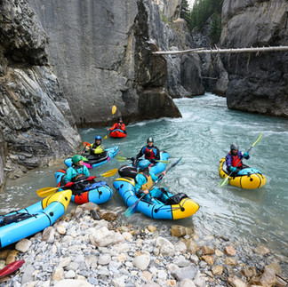
Box Canyon of the Cline (2.5km):
The final canyon of the Cline has been well known as a jewel of the Canadian Rockies paddling scene. If you don't have time or interest in the full multiday trip, it's well worth it to paddle this section as an out-and-back day trip. Day-trippers typically access this section from the northside trail before descending to river level by scrambling down Corral Creek. Whatever your access point, you are in for a treat. It's hard to capture the essence of the place in photos and is definitely better experienced than described. The general character is class II-III rapids that funnel through slots barely a boat length wide, all set within a fully committed class V environment. As mentioned above, this section would be substantially harder with moderate to high flows, and a piece of wood in the wrong place would be disastrous. In September 2025, there was plenty of wood suspended in the canyon, but all of it was well above river level and was indicative of the water levels during peak flows. With numerous caves, overhangs, and some fun play throughout, you'll want to take your time marveling at this unique stretch of river.


LOGISTICS
Permits:
Most of this trip is in the White Goat Wilderness, where you do not need a permit for "random camping." If you plan to camp within Banff National Park, on the west side of the divide, you need a backcountry permit. We did this as a 2-night trip, camping at Pinto Lake on the first night and at Sentinel Creek on the second.
Shuttle:
Unlike other multiday traverses in the Canadian Rockies that require exceptionally long shuttles, the Cline's shuttle is a simple 45-minute drive on paved highways. Given that the route begins in Banff, you will need a park pass to enter the park and leave your vehicle at the Sunset Pass Trailhead.
