
Packrafting the "River of Return" Loop: A 3-river, 150-mile route in Idaho
- Tim Kelley
- Dec 21, 2023
- 7 min read
Updated: Jan 15

Why Packraft the "River of Return":
While the Salmon River has long been home to the Nez Perce, early white explorers gave it the moniker of "the River of No Return," due to the foreboding nature of the canyon and its whitewater. These days, the Salmon is one of the most sought-after permitted multi-day river trips in the West, despite a long car shuttle. Enter packrafts, and there is now another and perhaps more compelling way to return to your vehicle. First packrafted in 2012 by Forrest McCarthy and company, the "River of Return" trip is a roughly 150-mile loop connecting the "Main Salmon" back to itself by way of a 40-mile hike and a paddle of its tributaries Big Creek and the Middle Fork. This loop showcases what is most special about packrafting by connecting a whole bunch of superb wilderness via great whitewater and scenic ridge-top hiking. Complete with hot springs, pictographs and excellent fishing, this route is truly a packraft classic and a great way to experience the Frank Church River of No Return Wilderness. For those with extra time and desire for whitewater, an out-and-back day trip on the South Fork of the Salmon is a worthy addition.
Route Overview:
Main Salmon: Corn Creek to Mackay Bar (61 miles)
This section is famous for its big sandy beach camps and forgiving class III wave-train rapids. Hot springs and pictographs are also worthwhile stops along the way. It is a beautiful, roadless section of river but feels less wild in comparison to Big Creek or the Middle Fork due to ranches and jet boat traffic along the way. Beginning a loop with a paddling section allows for some additional food luxuries at the start of the trip so long as you eat the weight before your big climb.


South Fork of the Salmon (optional)
The South Fork of the Salmon is another popular whitewater-packed tributary of the Salmon River. While paddling the South Fork is not a necessary part of the loop, a convenient riverside trail makes it a great out-and-back addition for those with extra time or whitewater ambition. While this run is well known as big water class IV-V in the spring, late summer and fall flows reduce the push and make it more of a technical boulder slalom that is class III-IV in nature. The biggest rapids of the run at Fall Creek are within the last 5 miles of river and make for an easy walk from the confluence. We enjoyed camping near the suspension bridge over the South Fork which also served as a convenient spot to stage for the following day of hiking.


The Hike: Mackay Bar to Big Creek (35-40 miles)
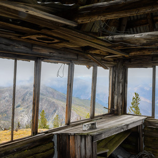
The hike between the South Fork and Big Creek gains a vertical mile's worth of elevation in the first 7 miles of hiking. There is very little vegetation on the ascent, which makes it a sweltering hike in the summer. Luckily, the trail is well constructed with dozens of switchbacks leading up the to the ridge top. Water is scarce on the ridge but the springs marked on map were reliable options for us. The horsepacker's camp at Quartz Spring, which has water access and great camping, is a convenient spot to end the first hiking day. Descending from Mosquito Springs, USGS quad maps show a few different options. While the original packraft route descended via a more direct fashion, recent fires and blowdown have turned the obvious options of descending via either Beaver Creek or Bridge Creek into a maze of ashen deadfall. We were reluctant to take the extended detour that adds 6 miles of hiking via the Chamerlain Springs Trail, but in the end were grateful to just follow a trail without having to do extensive route finding or log-hopping that the damaged trails now necessitate. Until the trails are restored, which may be years or not at all, heed the advice we received and take the Cow Corrals to Chamberlain detour (depicted on the embedded map).


Big Creek: Monumental Creek to Middle Fork Salmon (24 miles)
Where you inflate your boats to launch on Big Creek is very dependent on water levels. With tired feet, we were questioning why we hadn't put on as we walked along the riverside trail. Once we walked beyond the more channelized start of Big Creek, each shallow braid or river-wide logjam reaffirmed our decision making. Monumental Creek added a good deal of water to the flow and starting there should allow you to bump your way down in most low-water conditions. Aside from the final gorge, most of Big Creek is class II in character save for one tighter class III+/IV- boulder garden not long after Coxey Hole. Gravel bar camping is abundant until you reach the final gorge. Below the foot bridge at Taylor Landing Field, the river channelizes, the pace quickens and you are treated to some incredibly scenic whitewater all the way to the Middle Fork confluence. The river left trail allows for easy scouting, portaging or second laps! This section was III+ at our low flow and would be solid class IV in the spring.


Middle Fork: Big Creek to Main Salmon (18 miles)
The final stretch of the Middle Fork is arguably the most stunning part of the river as it cuts through the Impassible Canyon. Towering walls and fun, consistent whitewater makes this an excellent grand finale to the loop. Compared to Big Creek, the Middle Fork will feel like a real river in terms of relative volume and character. Rapids are in primarily class III-III+ (some IV in the spring) and all have scout and portage options at river level.


(My camera battery died so I have supplemented with a few phone photos and others from a 2017 trip.)
Main Salmon: Confluence to Corn Creek (4 miles)
At the confluence, the flow doubles again as you make your final left turn of the journey. The grand finale of the loop lies just downstream at Cramer Creek Rapid, which has the biggest hydraulics of the trip. Back at the boat ramp enjoy the curious looks you will receive from other boaters when they ask where you launched and you respond "right here!"
Possible Itinerary:
There are many ways to break up this loop. Here is our schedule from our low-water fall trip in 2023. This felt like a full itinerary for us but spring flow would allow for a slightly quicker trip. If you don't have a Middle Fork permit, you will need to allocate time differently so you can paddle that section in one day:
Day 1: Launch on the Salmon at Cache Bar, ranger check at Corn Creek, soak in hot springs upstream of Barth, paddle to Barth Hot Springs
Day 2: Paddle Salmon to South Fork confluence, transition, hike to South Fork bridge
Day 3: Day hike up the South Fork, paddle back to camp
Day 4: Hike up trail to Horse Heaven ridge, follow to Quartz Spring
Day 5: Continue on Horse Heaven ridge, at Mosquito spring head to Cow Corrals and take Chamberlain trail south, camp at juncture with old Beaver Creek trail
Day 6: Hike to Big Creek and continue hiking along river before transitioning to paddle at Monumental flat, camp at Hard Boil Flat
Day 7: Paddle all of Big Creek, continue on Middle Fork, camp at Redside
Day 8: Paddle remainder of the Middle Fork, continue down Salmon to Cache Creek boat ramp (half day)
When to go:
Determining when to go can be a little challenging. You will need 2-3 permits and to be in compliance with the seasonal closure for Big Creek. Hopefully this flow chart can help you navigate the process. Links to registration and additional permit information are also included below.

Permit Information:
Required:
Main Salmon Permit*: This permit is $4 per person per night. You will be guided through choices of your launch date, launch point, takeout point, and number of nights before placing your reservation and paying the fee.
Big Creek Permit: This tributary permit is free. Fill our this electronic form and send it to the email listed at the bottom.
Optional:
Middle Fork Permit*: This permit is only necessary if you want to camp on the 18 mile stretch between Big Creek and the Main Salmon. Most packraft parties just do this section in a day, often because their trip falls during the Middle Fork lottery season and they didn't win a permit. October trips will have an easier time securing a post season permit if they want to spend a night camping on this beautiful stretch.
Permit requirements*:
As is the case on many permitted western rivers in the United States, the Middle Fork and Main Salmon have a list of items that are required for any trip to carry. You will need to show these items to the ranger issuing your permit at the Corn Creek boat ramp. Given packrafters have the unique challenge of actually having to backpack with this gear, it is nice to find lightweight solutions that are still in compliance.
Permit Required Items: | Compliant alternatives for self-support kayak/packraft trips: |
Photo ID of the Permit Holder | Same (hard copy required) |
Porta Potty | WAG bags that can be disposed of in a landfill. These need to be stored in a hard sided container. We used a screw top plastic container per person (such as a protein powder jar). WAG Bags only needed to be used when camping on the river corridor. Cat-holing is appropriate for the backpacking portion. |
Metal Fire Pan | Even if you don't plan on having a fire you need bring a fire pan. A grocery store, disposable turkey roasting pan is a compliant alternative. |
Ash Container | You need a hard sided container to pack out your ash (could use the human waste container mentioned above). Just don't have fires and you won't have to worry about your ash capacity. |
Strainer | Chesse cloth or fine mesh screen. |
Shovel | Your paddle counts! |
Bucket | Your cook pot counts! |
Currently NOT required for inflatable craft under 10ft such as a packraft. This could change in the future so check the link. | |
Fire Blanket (Recommended) | Only recommended but may become required. |
River Maps:
For those looking for more information on camps and rapids on the Middle Fork and Main Salmon, the RiverMaps company makes a great guidebook for these stretches. If you just want to know where camps and rapids are, you can download their GPX file for free. Or just bring a USGS quad and treat it like a true expedition!