
Packrafting the Bridge-Stehekin Loop: A 45-mile route in North Cascades National Park.
- Tim Kelley
- Aug 27, 2023
- 6 min read
Updated: Jan 15

Why Paddle the Bridge-Stehekin Loop?:
This route pairs some of the best whitewater in the North Cascades with excellent wilderness hiking on a well maintained trail system that meanders through old-growth forest and alpine meadows. Bridge Creek has long been a sought after wilderness kayak run for advanced paddlers that comes with a few logistical challenges. Typically, kayakers do a 3-hour one-way shuttle followed by a 4-mile hike to access the river, and then finish the adventure by catching the once-a-day, 5-hour ferry across Lake Chelan. Doing this trip with a packraft allows paddlers to pack up their boats upon arriving at Lake Chelan and then hike back to their vehicle via the scenic McAlester Pass Trail. While the ferry is a charming part of the adventure, those that want to minimize their vehicle travel and don't mind stretching their legs will enjoy this route as a shuttle-free loop.
Difficulty: Bridge-Stehekin gets a class IV-V rating from American Whitewater. With high water and/or for those planning to paddle the short Tumwater Canyon section, this run should be considered a solidly class V endeavor. At our low flows and with a portage of Tumwater Canyon, I would give the run a class IV-IV+ rating. At 150 feet per-mile, the run is full of tight boulder gardens and stacked ledges that take on a congested and technical character with more of a fast-paced and pushy feel as flows increase. This is a far cry from an intro to class IV wilderness paddling trip and is best suited for class the class IV+ packrafter comfortable boat scouting steep drops.
Bridge Creek:
The start of the run is continuous class II-III broken up with an occasional class IV bedrock drop. This section will have you on your toes due to the limited eddies and high likelihood of encountering wood hazards. Once you reach the confluence with the North Fork of Bridge Creek, the volume doubles and the run steepens. Be ready to catch a river right eddy for a mandatory portage where the river corridor constricts between two bedrock walls after a relatively open section in the canyon. The last eddy above this unrunnable waterfall sieve is unassuming, so catch one early to scout the portage route. The portage itself has some exposed scrambling and slabby rock that could become very slick after recent rain. After the portage, more class IV ledges stack up before a bridge comes into view signifying the final significant drop of Bridge Creek. Here an island splits the flow into a right channel offering a vertical drop and a left channel offering a tiered drop with a fun slide.


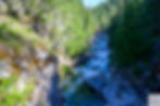
Stehekin River:
Below the Bridge-Stehekin confluence, the character of the run changes. The river doubles in flow and becomes pushier while also taking on a wider channel that allows for a variety of lines in many rapids. The first rapid below the confluence sets the tone for this section as it funnels down into a narrow and powerful slot that forms a significant hole at higher water. The pace then tapers to fun III+/IV- river running before ramping up once more on the approach to Tumwater Canyon with an extended sequence of IV-IV+ boulder garden rapids. After passing below the first bridge over the Stehekin, one more rapid follows before a rocky beach signals the Tumwater campsite (a good camp option and the best spot to start a scout of the canyon).


Tumwater Canyon:
Either the biggest whitewater of the trip or an easy portage, this class V canyon deserves a scout either way. The entry rapid is one of the more significant drops of the canyon, but there are more downstream with higher consequence. River-level portaging of most rapids seemed possible at low-medium flows (albeit a bit involved), but it is worth noting there is one more committing drop near the end of the canyon that seems difficult to scout and not possible to portage at river level. Low flows revealed lots of sieves that will fill in with more water, but that extra water would make the whitewater very pushy. For those uninterested in running Tumwater, a 3/4 mile walk on the river right gravel road makes for a quick portage. Make sure to put-in at the trail access just above High Bridge to get a few more class IV drops.
Stehekin below Tumwater:
Below Tumwater Canyon, the river tapers to class II with more open views of the surrounding mountain scenery. The river splits into occasional braids where you can expect to find some wood. We did one portage around a log jam in the summer of 2023. The final miles are frequented by guided fishing groups in rafts.

Flows: This run is typically paddled mid-summer during the snowmelt season. The often recommended range is between 2,000-4,000 cfs on the Stehekin gauge. Given the gauge is near the mouth of the Stehekin, even at high flows, you will have just a few hundred cfs at the start of Bridge Creek before watching the river double in size with each major confluence. While the hydrograph suggests that historically mid-July is the best time to catch this run with water, the summer of 2023 brought an early melt followed by prolonged dry conditions that left us with less water than we had hoped for. Given I had secured a backcountry permit with desirable camps for a packraft loop during the permit lottery in April, I felt committed to the trip, undeterred by low flows, and optimistic that packrafts would make the conditions more enjoyable. Worse case scenario, we would take the boats on a scenic backpacking loop. We found that at our flows between 1,100 and 1,000 cfs, Bridge Creek channelized well and still provided some enjoyable low water creeking once we had passed the North Fork confluence. By the time we reached the Stehekin, there was plenty of water and, in comparison to the creek we had just paddled, we could feel the extra push.
Put-in recomendations based on flows (for packrafters):
>2000 cfs- Fireweed Camp (3.3 miles from Bridge Creek Trailhead): The first put-in option, boney at most flows with high wood potential.
>1500 cfs- South Fork Camp (5.9 miles from Bridge Creek Trailhead): We put-in here at 1,100 cfs but wish we hadn't. It was boat abuse with no upside. With more water, this is continuous II-III boogie with an occasional drop.
>1000 cfs- North Fork Camp (9.6 miles from Bridge Creek Trailhead): While it is nice to paddle when it becomes possible, the rapids above the North Fork are not very noteworthy, so if you have to walk down to here, don't dispair. The quality whitewater is still downstream!
The photos below give a sense of the extreme low flows we experienced between the South Fork Camp and the North Fork before levels doubled and became enjoyable:


Permits: Overnight camping in North Cascades National Park requires a backcountry permit. This entire packraft route travels through a designated "high use" area which means that camping is restricted to established, reservable sites both on the river section and on the return hike. For paddlers, this can present a challenge as we often plan trips short notice to align with favorable water levels. Campsite reservations can be obtained through an online lottery months in advance or on a walk-up basis. While there is no guarantee that river levels or your preferred campsites will align perfectly, this is still a worthy trip. It's required for paddlers to go through the process of getting permits, and it's important to concentrate impact in designated areas and help maintain good standing for paddlers with the National Park Service.

The Return Hike: From the take-out at the lake, no trip seems complete without a stop at the Stehekin Bakery which has lots of delicious food options and a large grassy lawn that was a great place for us to dry our gear. The return hike to the Bridge Creek trailhead is 18 miles with a gross gain of 6,200 feet. While the trail does a lot of climbing, it is quite well-maintained and, save for the first few miles to Rainbow Ford, is mostly shaded.


Sample 3-night/4-day itinerary from our low water trip:
Day 1: Hike from Bridge Creek Trailhead, camp at South Fork.
Day 2: Paddle Bridge Creek into the Stehekin, camp at Tumwater.
Day 3: Paddle Stehekin to lake, transition, hike to camp at Rainbow Ford.
Day 4: Hike over McAlester Pass to Bridge Creek Trailhead