
Multi-day Packrafting in New Zealand: A South Island guide from a visitor's perspective.
- Tim Kelley
- Nov 1, 2024
- 14 min read

Updated: Jan 15

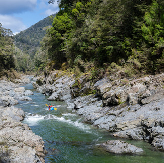
Why Packraft New Zealand (Aotearoa)?: The South Island of New Zealand has long been a mecca of whitewater kayaking known for its mind-boggling schist gorges and steep boulder gardens. While geographically small, the South Island's many roadless areas and rugged landscape have meant that helicopter access kayaking has been the predominant way to experience rivers on the West Coast. New Zealand has been of growing interest to packrafters due to its unique access considerations and amazing backcountry infrastructure. With thousands of kilometers of well-signed and maintained trails and the ability to sleep in huts on most nights, it's no wonder that packrafters have taken an interest.
In this post, I plan to deviate from my typical style which provides maps, photos, and logistics information for one specific trip. There is so much current information and so many trip reports linked at Packraft Trips NZ that individual write-ups might be superfluous. All the information provided is based on one lap of each section described. While not intended to serve as a comprehensive guide, hopefully, it offers a snapshot of the runs from our perspective that could serve as a starting point in your adventure planning. I hope to synthesize each of the 10 multi-day trips we did during our month-long visit into a concise overview using the following format:
Overview | The general character of the trip and what makes it special. |
|---|---|
Length | The number of days required to complete this trip and a possible itinerary. |
Grade | The difficulty of this run at recommended levels. I have settled on the grade after taking into consideration the rating from the New Zealand Whitewater guidebook, other packraft trip reports, and our personal experience. South Island rivers are dynamic and steep. For most, the ratings feel stiffer than in North America with geology that tends to produce more sieve hazards. |
Flow | Online gauge, stick gauge, or a visual approximation of level information as it pertains to packrafters. |
Hike | Route access, trail conditions, distances and alternative access points. |
Covered in this write-up from south to north:
Why these 10 trips?:
I'm certainly not claiming that these are the "best" packraft trips New Zealand has to offer. There is much more whitewater in New Zealand than we could see in a month or even a lifetime. Ultimately, we prioritized multi-day trips that required hike access while falling in the III-IV+ range. My methodology was little more than exploring Packrafting Trips NZ, the New Zealand Whitewater Guidebook, and taking recommendations from friends and local packrafters. It is worth noting that it was just two of us on each of these trips and we just had one vehicle. As such, we picked trips that were out-and-backs, loops, or short hitchhikes to maximize our time paddling and minimize our time driving. As a result, there are a few trips that didn't meet these criteria that I will prioritize if a return trip happens, such as the Landsborough and the Waitoto. Below are the trips we did while visiting the South Island in November-December 2023 ordered from south to north.
Pyke-Hollyford:
Overview | The Pyke-Hollyford Loop is an incredible way to experience Fiordland and is appropriate for almost all abilities. Go during a nice weather window because this loop is all about views, not whitewater. There are some big lake crossings, scenic beach hiking, and likely marine wildlife encounters along this lollipop-style loop that has a great paddle-to-hike ratio. |
|---|---|
Length: 4-6 days | We did this as a 4-day, 3-night trip staying at Hokuri, Big Bay, and Olivine Huts. 4 nights and 5 days would be a more relaxed pace. |
Grade: I-II (P) | Mostly fast-moving water, the Hollyford has a lot of dead snags throughout and basic maneuvering skills are necessary. There is one portage of a serious rapid with an obvious horizon but an easy trail on river right. We elected not to bring helmets. The lake paddling would be the biggest hazard in windy conditions. |
Levels: Visual | Perhaps there is no high water cutoff to this run but you would want to have solid class II skill after a big rain event given the prevalence of wood along the Hollyford. |
Hiking: 35km/22mi | While these days packrafting is a common way to see the loop, it has long been a backpacking route. The hiking sections are on well-maintained and signed trails. |


Young-Makarora Loop:
Overview | A way to turn the well-known Gillespie pass trek into a packraft loop route. Gillespie Pass offers stunning views of the Southern Alps. A detour to the iceberg-filled Crucible Lake is a worthy addition. While I had read an account of this route done as a counter-clockwise packraft trip, exiting via the Wilkin (Class I), that trip is a horseshoe and requires a vehicle shuttle. We decided to go clockwise to take advantage of the Young and Makarora Rivers to paddle back to our vehicle at the trailhead. |
|---|---|
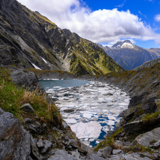
Length: 4 days | We camped at Wilkin Forks, Siberia Hut, and Young Hut. On day two we dropped our stuff at Siberia hut and hiked up to Crucible Lake for a scenic detour before returning to the hut. |
Grade: IV-IV+ | The Young starts flat before tumbling through a scenic gorge. The trail is never far away if you find yourself in over your head. Just know that it gets steeper all the way to Ram Flat. There is a cool 3m drop on the run but, while photogenic, it is one of the easier drops and doesn't convey the overall steep boulder garden character. You'll want to be a solid class IV paddler to enjoy this or you will likely be portaging lots. If you are not, doing this as a counterclockwise horseshoe would be a great way to bring a packraft, and allow you to float out on the Wilkin. |
Flow: Visual | Kayakers like this after rain when the river is slightly discolored which seems to up the difficulty to IV/V according to the guidebook. We went 3 days after heavy rain and found it to be running clear and at a perfect medium-low level. |
Hike: 37km/23mi | The hike begins up the Wilkin Valley which requires crossing the Makarora (fordable at low flows or inflate the boat to ferry across if it is high). The track is very well-signed and easy to follow given it is a popular backpacking loop. Many backpackers seem to prefer doing the loop in the other direction but we found the clockwise climb over Gillespie Pass more gradual than it would have been from the east. This route has a gross elevation gain of 2050m/6730ft, so expect a calf-burner! |


Copland
Overview | The Copland offers a great one-night adventure complete with stunning mountain views, hot springs, turquoise water, and engaging rapids. |
|---|---|
Length: 1-2 Days | We hiked in and stayed at Architect Creek Hut for a night before doing a morning trip to the hot springs at Welcome Flat. |
Grade: III-IV | Most of this run is class III in nature save for two sections of class IV, one of which is visible from the trail. Everything is scoutable and portageable at river level. |
Flow: Visual | No gauge, just visual. I would imagine this gets too low come mid-summer unless there have been recent rains. |
Hike: 9.6km/6mi | The hike from the car park to the put-in at the Architect Creek hut is only 3 hours on a very well-maintained trail. From the hut, you can cache your gear and hike 7.4km/4mi (one-way) to Welcome Flats to enjoy the hot springs and stellar views. |
Tip | The Architect Creek Hut is only a 2-person hut, so go early if you want to get a bunk. Welcome Flat Hut requires reservations. |


Whataroa:
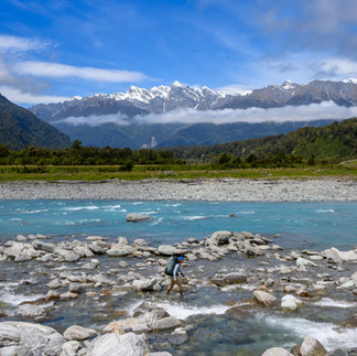
Overview | A well-known West Coast fly-in, the Whataroa is also easily accessible on foot. It is known as one of the most scenic gorges in the region with nice views of the Southern Alps as you hike to the put-in. |
|---|---|
Length: 1-2 Days | It's a half-day hike up to Barrowman Flat and you will want to start paddling at a reasonable time if it is your first time down. Camping at Barrowman is possible for those seeking a multiday. |
Grade: III-IV+ or II+/III- | The gorges of the Whataroa are considered a great first "fly-in" trip for kayakers. They are moderate in comparison to their neighbors but are still a serious undertaking given their environment. They are largely IV in nature with the entry rapids to the gorges being a half step harder (IV+). Portaging the hardest drops should be possible (with a little scrambling) at recommended levels. Below the swingbridge the river eases to playful II+/III-. |
Levels: Online Gauge | The guidebook recommends 40-70cms as a good first-time flow for the gorge with it becoming quite pushy when higher. This run should remain paddleable well after rain and when everything else is low. The pictures below are at a flow of 60cms. |
Hike: 10.7km/ 6.65mi | The track up the Whataroa crosses private land. Before you start your hike, call the number of the land owner posted on the gate at the car park to get permission. The track meanders in and out of fields and along the river's left bank before reaching the swinging bridge in about two hours. Put in here for the lower run or cross the bridge and continue another hour up to Barrowman Flat. |


Wanganui
Overview | Unlike many of its neighboring drainages that flow through sheer-walled canyons, the Wanganui is a broad valley offering great mountain views, hot springs, and splashy whitewater. |
|---|---|
Length: 1-2 Days | We paddled the Wanganui as a full-day trip but others have enjoyed hiking up to Hunters Hut and paddling out the following day. |
Grade: III+ (V) | III+ (IV/V): Boulder gardens near the start taper to wave trains amongst braided channels near the end. Most of the run is class III save for the "slip rapid," which begins just above Steep Creek. This steep boulder garden is class IV/V with some sieve hazards but can be easily portaged on the river right before enjoying the III+/IV- runout. |
Flow: Visual | The wide valley and braided channels of the Wanganui can handle more water than some of the steep and more constricted valleys of the West Coast. We went after a day of rain and found it to be a nice medium flow. The neighboring Whataroa gauge should help you get an estimate. I would avoid going during heavy rain due to the landslide hazard throughout the hike. |
Hike: 14.5km/9mi | Due to some recent washouts, the track up the river left is slow going in some places as you climb in and out of drainages and over debris. Most of the time it is easier to travel over the rocks at river level and then find the orange blazes when you get cliffed out. We made it to the confluence with the Lambert in 6 hours. |


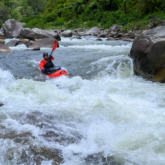
Taipo
Overview | A beautiful alpine river with a continuous character. This trip can be done as an out-and-back or a traverse. The higher you put in the more challenging the whitewater. |
|---|---|
Length: 2-4 days | We did this trip as a 2-day out-and-back with a night at mid-Taipo Hut. If you access the run from Harman Pass you will need 1-2 more days as well as a shuttle. |
Grade: III+ | Very continuous, with steep boulder gardens up top that taper to easier wave trains by the end. The action is non-stop and intermediate paddlers may want to scout some of the initial horizon lines while advanced paddlers will find things to be boat-scoutable with fun moves, boofs, and eddies throughout. |
Flow: Stick Gauge | You can find the stick gauge on the downstream, river-right pilon of the take-out bridge. We read a report that 2.4 was an appropriate packraft level but I imagine any lower would be quite boney. We found 2.5 to be well-channelized but not pushy. Kayakers seem to look for 2.8 or above. This river would quickly become a non-stop freight train of class IV with anything significantly higher. |
Hike: 17.8km/11mi | From the car park, the track follows a two-track road before becoming single-track, eventually crossing a walk wire to the river left and continuing to mid-Taipo hut. |
Alternative Access | For those looking to extend the adventure with an alpine hike and some additional whitewater, accessing the Taipo from Harman Pass adds another day to the adventure. If you put in at Julia Hut expect some portaging and solid IV-V whitewater or continue hiking to the swing bridge for an easier warm-up. |


Waiau
Overview | High country scenery paired with excellent whitewater. The standout feature of this run is its intermittent canyon sections that provide engaging whitewater in a spectacular setting. |
|---|---|
Length 3-4 days | We accessed this run from Lewis Pass via the St. James Walkway. We took 3 nights to complete the trip staying at Cannibal Creek Hut, Christopher Creek Hut, and then camping riverside on a gravel bar beyond the Narrows. |
Grade: III-IV(V) | Good class III-IV throughout. There are three canyon sections where the rapids are more constricted and ledgy interspersed with boulder garden rapids between canyons. The Narrows is a more consequential, sustained canyon section (V) that is an easy portage via a 4WD road on river right. |
Flow: Online Gauge | While some trip reports have suggested low water is ideal for packrafters (even as low as 40cms) we appreciated doing this run after a recent rain. The flow spiked to 80cms when we put on which made Ada Creek paddleable from Chistopher Hut. |
Hike: 23km/14mi | We accessed the run via the popular St. James Walkway starting at Lewis Pass. While not the most common or shortest access, it is a scenic and interesting hike with nice huts along the way. We ultimately settled on this access because it offered the simplest hitchhike to return to our vehicle at the end of the trip. |
Alternate Access | For those looking for a shorter approach (1/2 day vs. 2 days) consider accessing the river via Mauling Pass. This is the access kayakers tend to use as it is a shorter, alpine approach on a 4WD road. |


Mokihinui
Overview | Emerald green waters with boulder garden rapids of a pool drop character. The Old Ghost Road parallels the river which makes for simple out-and-back logistics. |
|---|---|
Length: 2 days | One day hiking the Old Ghost Road to Mokihinui Forks Hut, paddle out on the second. |
Grade: III-IV | Between Mokihinui Forks Hut and Specimen Point Hut, the run begins with class IV rapids as the river drops through a chunky limestone section created by an earthquake slip. You can put in below Specimen if you want an easier run. Splashy rapids separated by big emerald pools take you the rest of the way. |
Flow: Online | There is an online gauge as well as a stick gauge near the takeout. High flows would make this run solid class IV. |
Hike: 20km/ 12.5mi | Starting from the west end of the Old Ghost Road, there is an excellent track with frequent bridges to Mokihinui Forks Hut. Be on the lookout for mountain bikers as this section is the exit to a popular multiday, single-track route. |


Karamea:
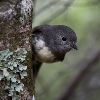
Overview | An incredible way to visit Kaharungi National Park. A lush forest approach teeming with bird life brings you to a pristine river full of freshwater eels and plenty of boulder gardens. |
|---|---|
Length: 4-6 days | Our itinerary was 4 nights and 5 days staying at Taipo, Venus, Roaring Lion, and Grey Hut. Having some flex days to wait out spiking flows should be a consideration on this route. |
Grade: IV (V) | This depends on who you ask. I thought the class III+ (V) rating in the kayak guidebook would sandbag intermediate packrafters while the class V rating on New Zealand packraft is an oversell. If you have solid wilderness class IV packraft experience this run should be manageable and fun at LOW flows. Roaring Lion Rapid is the one extended class V section with sieve hazard but is it easily portageable over the talus on river left. High water is best avoided for all but seasoned class V paddlers familiar with the run. |
Flow: Online Gauge | For your first lap packrafting, look for 0.9-1.1 on the gauge. We launched with 1.1 and ended with 0.9. At low flows, the last day offered up some pretty splendid IV-IV+ but could become terrifying with too much water. Flows drop just as quickly as they rise. Budget an extra day or two to wait out any significant rain. |
Hike: 30km/ 18.5mi | While multiple access points exist, accessing this run from the West Coast via the Wangapeka track makes for the easiest logistics. The trail was steep and slick for us in wet conditions but very easy to follow with scenic views from the top of the pass. We took 1.5 days to complete the hike before launching on the Karamea at Trevor Carter Hut on the afternoon of day two. |
Shuttle: | While this C-shaped route means your start and end points are not too far apart, a shuttle is still helpful given hitchhiking seems unlikely from the dead-end roads at the start or finish. We hired Karamea Express to bring us back to our car at the start of the Wangapeka Track. |


Pelorus
Overview | An excellent beginner-intermediate trip with pool-drop whitewater and scenic gorges. A lower access point makes this a good option for beginner paddlers or groups of mixed ability. |
|---|---|
Length: 2-3 days | We hiked into the river, paddled the first gorge, and stayed at the Middy Creek Hut before paddling to the road bridge the following day. An extra night would make for a more leisurely trip at low water (Roebuck, Captain Creek Huts). |
Grade: II-III | The first gorge between Roebuck and Middy Hut is class III/III+ with limited scouting opportunities. The remainder of the run eases to II+/III-. |
Flow: Online Gauge | Look for 15cms for a channelized low. We didn't check the gauge and determined that, while possible at 7cms, we definitely wouldn't recommend it! |
Hike: 16km/10mi | A well-maintained sequence of tracks. The Hacket and Browning Tracks take you to the Totara saddle before the Pelorus Track does a rooty, descending traverse to the river. |


Additional Resources:
Trip Reports and Guidebook.
Packrafting Trips NZ: A comprehensive source that is a good place to start planning your New Zealand Packraft adventures. The interactive map is color-coded to denote the difficulty of whitewater sections and hiking access. Clicking on any of these segments will open an attached trip report.
New Zealand Whitewater (5th Edition): This paperback guidebook has descriptions for 180 runs across both islands (including 8 out of the 10 rivers covered in this write-up). This book is written from the perspective of a seasoned, class V kayaker and includes many harder runs not covered on the Packrafting Trips NZ database.
Pro Tip: We found using these two resources in conjunction and averaging the ratings served as the most accurate portrayal of each run.

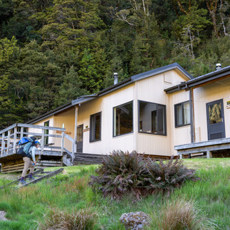
Huts: The Department of Conservation (DOC) manages over 950 huts around New Zealand and it's what makes backcountry travel in New Zealand so pleasant. Most huts have bunks with mattresses, a cooking surface, a rainwater cistern, and a pit toilet. We stayed in huts ranging from a 2-bunk hut to 20-bunk huts that each had a unique character. It was fun to puruse each hut's log book to see the steady growth in packrafting on some of these rivers over the last decade. We bought a 12-month hut pass for $160 NZD which it quickly paid for itself. We often would try to finish a trip in the morning, re-ration, and then head out on our next trip to stay in a different hut that evening.

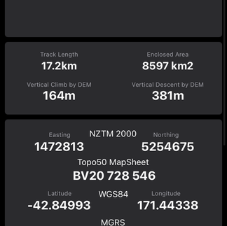
Maps: The embedded map should provide helpful details regarding the various routes described above. I would also recommend purchasing and downloading the NZ Topo50 app (South Island) which will give you offline access to maps and GPS. The app has New Zealand-specific overlays such as DOC tracks and huts as well as route profiles and approximate hike times.


Flow Info: We downloaded the app Flow Rate Aotearoa which was a convenient way to bookmark gauges. It has an easy-to-use interface that shows hydrographs, trends, and current weather.


Travel Tips:
Camping: To find simple campsites between river trips we used the NZ Topo50 App and filtered for DOC campsites. Typically these sites have a pit toilet, picnic tables, and water.
Holiday Parks: Holiday parks are in many towns across the South Island. They are typically equipped with showers, laundry, indoor communal kitchen space, and wifi. While a little more expensive than a DOC campsite, they are still much cheaper than other lodging and offer a nice spot to reset between trips.
Cell Service: While not essential, we appreciated having a SIM card and data for Google Maps directions, forecasts, and flow information while we were traveling. We found prepaid SIM cards at the Queenstown Airport that allowed us to add data as we needed.
Hitchhiking: We only had one vehicle so we often hitchhiked to complete shuttles. Compared to the culture in North America, where hitchhiking can be both challenging and taboo, hitchhiking in New Zealand is much more commonplace. While there is always an inherent risk to hitchhiking, especially as a solo traveler, we were never waiting for a ride for more than 30 minutes and typically met helpful, friendly locals.

Comments