
Packrafting the Hornaday's Lower Canyons: Whitewater and Wildlife in Tuktuk Nogait National Park
- Tim Kelley
- Dec 4, 2025
- 10 min read


Why packraft the Hornaday?:
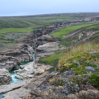
Situated in Tuktuk Nogait National Park and Inuvialuit land in Canada's Northwest Territories, the Hornaday River offers a one-of-a-kind Arctic packrafting experience. Receiving single-digit visitor totals each year, Tuktuk Nogait encompasses a pristine slice of barrenlands tundra home to musk ox, the Bluenose Caribou Herd, grizzly bears, and a plethora of bird life. Bisecting the heart of the park, the Hornaday River interrupts the rolling tundra as it carves a sinuous and awe-inspiring sequence of canyons on its way to the Arctic Ocean. For packrafters, the river's Lower Canyons offer incredible, crystal clear water, engaging pool-drop rapids, and stunning geology, all accessible via excellent walking across the tundra, along the canyon rim.

ROUTE OVERVIEW
History: While the Lower Canyons of the Hornaday haven't been known as a paddling destination, the upper Hornaday River is a canoe route that traverses an open tundra landscape known for excellent wildlife viewing, fishing, and simple whitewater. In its final 50 miles, the Hornaday River undergoes a dramatic character change, as it steepens its descent to the ocean, cutting 3 distinct canyons along the way. This substantial increase in difficulty means that canoe parties charter flights out from Uyarsivik Lake above the head of the first canyon. In 1999, shortly after the creation of Tuktuk Nogait National Park, a team of kayakers did the first descent of the Lower Canyons, running every rapid aside from the 20m La Ronciere Falls, and documenting their trip in a report produced for Parks Canada. More recently, Steve Evans paddled and portaged his packraft from Uyarsivik Lake through the Lower Canyons during a solo, 11-day trip in 2023. Steve put together a more detailed history of attempted descents as well as a meticulously annotated map, which was a useful tool in our planning process.
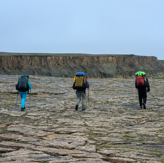
Prior to our trip in 2025, other expeditions to the Lower Canyons accessed the river via a charter flight. Looking for every way to minimize costs on a remote, logistically intensive trip, we planned to access the river by doing an overland hike from the commercially serviced village of Paulatuk. Not only did this route reduce our costs, but it was an enjoyable way to see the park from another perspective while allowing us to scout the canyons along our way. We did this 185km/115mi route over the course of 10 days, spending about 6 days hiking and 4 days paddling. While this length was an appropriate amount of time to complete the route, we agreed that an additional day would have been nice insurance for delayed flights or bad weather.
Difficulty: The incredible remoteness of this trip adds to the consequences of any objective hazards along this route. Based on our experience during our late July water levels, I would give the Lower Canyons a III-IV (V) rating: most of the whitewater falls within the class III-IV range with one rapid that is class V. Aside from the class V section and a portage around a 20m falls, the remaining rapids have a pool drop character and are reasonable to scout and portage at river level. For those uninterested in running the class V section, we found that this crux is portagable, and I have provided more details in my description of the 2nd canyon. Generally, this run is best suited for class IV paddlers who will be able to comfortably boat scout and enjoy running some of the more technical drops. While class III paddlers might also enjoy this trip, they would benefit from more time built into the itinerary to allow for more frequent scouting and portaging.
Season/Flows: At this time, the few descents of the Lower Canyons have happened in mid to late July. The early summer melt in the tundra is fast and furious, and I wouldn't want to be in the canyon at anything approaching high flows. The Hornday River does have a gauge located right near the park boundary. During our late July trip, the river was flowing at around 2.9m. At this level, the canyons felt like a well-channelized, medium-low level. Once below the final canyon, the river becomes shallower as it widens and braids, and you can expect to do some hunting for the deepest channels. The graph below shows the water level during the summer of 2025 as well as the specific time frame of our trip.

ROUTE DESCRIPTION
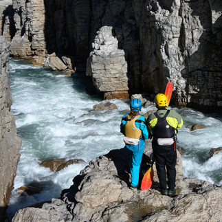
The Hike: After arriving in Paulatuk, we were greeted at the airport by the park manager, Craig, who took us to the Parks Canada office, where we had a brief orientation. While we were planning on walking the short section of road that leads out of town, Craig offered us a ride to the end of the gravel, which was a nice way to jumpstart the trip. From there, we ascended onto the plateau to the south, which offered spectacular views of the Arctic Ocean and generally nice walking in whichever direction we chose to travel. The first few days of the hike, we took a more direct route away from the winding course of the river before returning to the rim at La Ronciere Falls. While cutting across the tundra to the head of the first canyon would be the most efficient route, we found that following the rim was a more scenic option. Not only did we appreciate getting a view of La Ronciere Falls from above, hiking along the rim also allowed us to scout much of the whitewater in the 1st and 2nd canyons.


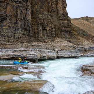
1st Canyon, III-III+:
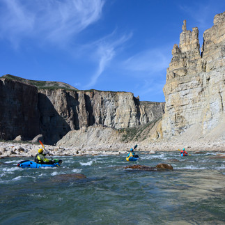
The 1st canyon serves as a great warm-up to the whitewater of the Hornday. Set amongst low walls, this section contains a few rapids named by the first descent party, such as Table Top and Rollercoaster rapids. At our water levels, these rapids were no more significant than many of the unnamed rapids in the Lower Canyons, and they will give you a sense of what to expect. We took a half-day to paddle this section before camping shortly after the start of the 2nd canyon.


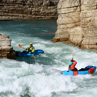
2nd Canyon, III-III+ (IV-V):
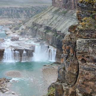
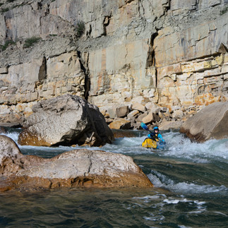
The 2nd canyon had been considered the crux of the Lower Canyons of the Hornday. This section of river flows through an incredibly sheer corridor of rock with consistent whitewater, ending with a narrows called "Pinball Canyon", a slot more reminiscent of something you would expect to find in the Desert Southwest than in the Arctic. It's a stunning canyon that is largely class III+ in character, save for a more challenging sequence that bookends a class V rapid called Gilbert's Delight. While this section is unportagable at river level, our party found it reasonable to scout, enjoyable to paddle, and very possible to portage on the rim without forgoing the other highlights of this canyon.
Above Gilbert's:
After a flatwater float exiting the first canyon, the second canyon begins abruptly with gate-like walls flanking a class III+ ledge sequence easily scoutable from a giant slab on river right. From here down to Gilbert's, the river winds its way deeper into the canyon with consistent class III rapids and a few nice ledges that offer scenic camping.


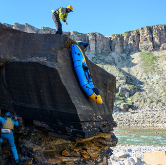
Portaging Gilbert's:
Given that the overall character of the Hornday is pool drop class III-IV with easy opportunities to portage, the existence of an "unportageable" class V might deter otherwise capable parties from attempting this section. While there is no river level portage, we found this section to be more reasonably portageable than previously understood. While I typically avoid providing this level of detail about a single feature, it seems relevant to share the details of our findings to help provide a more complete picture of the nature of this crux section for those contemplating a trip.
You don't have to portage the entirety of the 2nd canyon to portage Gibert's; there is egress from the canyon shortly above the rapid and return access shortly below that allows paddlers to portage the class V while re-entering above the fun and stunning "Pinball Canyon". If you plan to portage Gilbert's, it is easiest to catch an eddy on river right along the large rock slab at river level. From this rock bench, multiple gullies allow for quick access to the rim via a 3rd class scramble. The member of our party who did this portage appreciated doing a quick transition into backpack mode to have both hands available for the ascent. It's easy walking for about a half-mile along the rim before a weakness in the canyon walls permits a descent to a big pool via another 3rd class gully.
Gilbert's Delight Portage: A downstream view of the final spot to exit the canyon.

Gilbert's Delight Overview Map: rapids and portage detailed
Paddling Gilbert's:
This class IV-V section is a short but steep sequence of rapids totally hemmed in by vertical canyon walls. To scout the rapid, we caught an eddy on river left before the class IV lead-in and scrambled along the bank to a great viewing platform. Don't commit to the river left scout until you have confirmed you can ferry back across to the river right portage eddy (higher water levels might eliminate this option). We ran Gilbert's entering center and then moved far left to punch the last hydraulic. Lots of rockfall suggest the rapids in this canyon could change frequently. There is one more class IV ledge not visible from the scout before the end of this more committing section.


Below Gibert's:
Below a large pool, the river re-enters another beautiful constriction. A straightaway class III slot followed by a powerful III+ flume leads to one final break in the canyon before the river enters a stunning flatwater slot known as "Pinball Canyon". The end of this narrows marks the end of the second canyon, and it is worth getting out and exploring the massive rock patio on river left, filled with potholes and plunge pools.


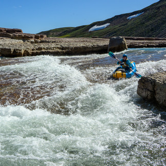
3rd Canyon, III-IV:
Above La Ronciere Falls:
The first rapid of the 3rd canyon is named La Petite Ronciere. Here, the river splits around an island with an unrunable right channel and a runnable sequence of slides and ledges on the left that can be scouted or portaged via the midstream rock island. Below, the river continues through a consistent sequence of class III-IV boulder gardens all the way to La Ronciere Falls.


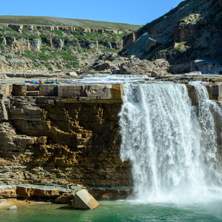
La Ronciere Falls:
While hiking the route along the canyon rim allowed for an amazing view of La Ronciere falls days prior, it was something else to behold from the lip. A huge eddy precedes the falls, and there is no mistaking the river right takeout. There is incredible camping on a wrap-around, elevated patio next to the falls. When it's time to portage, there's a crack at the end of the giant rock slab that offers an easy downclimb back to river level.


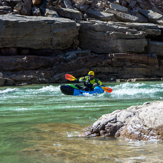
Below La Ronciere Falls:
The whitewater resumes immediately below the falls in a more continuous boulder garden character. Everything is easily scoutable and portageable from river level. After a few miles of quality class III-IV, the whitewater begins to step down to class II while the scenery becomes even more dramatic. The lower section of the 3rd canyon is the deepest part of any of the canyons, surrounded by impressive walls and towers. Once you hit Aklak Creek, the canyon broadens, and there are more camping options.


Below the Canyons, I-II:
When the canyon wall peel back, the river begins a more meandering course through rolling tundra. While some riffles and the occasional class II rapid break up the flatwater, the change of pace allows for ample opportunity to look for wildlife. There is no shortage of camping along this section, but it is worth looking for spots with a little protection, as strong winds off the Arctic Ocean are common.


Rat Lake Road:
Our trip ended as it began, on the only stretch of road leading to and from Paulatuk. This time we traveled the road's length on foot, which offers great views of the town and the Arctic coast.


LOGISTICS
Permits- As a small, remote park, obtaining a permit is a more personalized experience than I've had at any other national park. In addition to providing a detailed itinerary, we were asked to provide swiftwater rescue credentials for each member of the expedition as well as proof of rescue insurance (with minimal resources and a small budget, the park wants to ensure it is not on the hook for any costs associated with an evacuation). Once the application is submitted, it is reviewed by the park board for final approval. We found it really easy to work with the park manager, Craig, who helped us at each step of the application.
Flights to Paulatuk- Aklak Air offers 3 flights a week (Tu, W, F) between Paulatuk and Inuvik. We had no problem flying with isobutane fuel, but Aklak does not permit flying with bear spray. As such, the park office in Paulatuk is ready to outfit visitors with spray during their orientation. This region of the Arctic is known for its dense coastal fog. It is not uncommon for low visibility to delay flights into and out of Paulatuk, so having some flexibility in your travel plans is key.
Inuvik- The hub for many western Arctic communities, you'll likely end up spending a night in Inuvik en route to Paulatuk.
Getting to Inuvik: For those already in the north, driving to Inuvik is possible on the Dempster Highway. It's a long gravel road that can be an adventure in and of itself, and many prefer to fly to save time and wear on their vehicle. Local flights from Whitehorse and Dawson City are regular and reasonably priced with Air North. Those coming from southern Canada or the lower 48 can find connecting flights through Whitehorse with Air North or through Edmonton with Canadian North.
Getting into town: The airport is far enough from town that it would be a real slog to walk. Inuvik has an impressive taxi culture for a small town, and it seems to be the way to go to and from the airport. Each taxi company has agreed on the exorbitant fixed rate of $100CAD. If you're willing to drive to Inuvik, one benifit would be saving some money on taxi and camping fees.
Groceries: Like in any northern community, prices are high in Inuvik, so it's best to bring all your camping food with you and try to avoid shopping in town. In the case that an airline loses your duffel of food (speaking from a tragic personal experience...), Stanton Distributing on the north end of town has a better selection than the more centrally located Northmart.
Camp Fuel: If you flew to Inuvik, you'll need to find camp fuel. White gas was easiest to find, and it is available at both Northmart and Home Hardware Building Centre. Isobutane (for canister-style stoves) proved to be much harder to find but was available in a small quantity at Home Hardware, in a separate warehouse that offers some outdoor supplies. It is worth calling ahead to determine if it is in stock.
Camping: Happy Valley Campground is just a few blocks from "downtown". It does the trick if you want a shower and don't want to spring for the pricy and limited hotel options.


Comments